Archaeological Geophysics – launch of map service argin.no
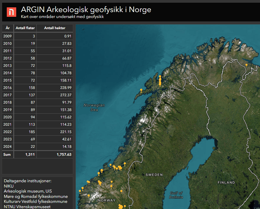
NIKU (with partners) has created an open map service with an overview of projects completed with archaeological geophysics in Norway. Almost 2000 hectares have been studied and 300 project reports are now available through the webpage argin.no.
About tha map service argin.no
- argin.no is a mapping service that provides an overview of areas surveyed using ground-penetrating radar (GPR) in Norway from 2007 to the present.
- The service is free and open to everyone. It is hosted on ESRI ArcGIS and is continuously updated with new data by the Norwegian Institute for Cultural Heritage Research (NIKU).
- Data is delivered from different actors: NIKU, The University Museum – NTNU , Vestfold County Municipality, University of Stavanger – Museum of Archaeology, and Møre og Romsdal County Municipality.
Since 2007 and until today, several archaeological geophysical surveys have been carried out in Norway, and publicly available reports from these surveys are made available through NIKUs map service argin.no.
– For NIKU alone, we are now approaching 250 different archaeological ground-penetrating radar studies, says Knut Paasche, head of NIKU’s Department of Digital Archaeology, – and all of these can be found in the Argin map service.
The mapping service provides a nice overview of areas in Norway where high-resolution archaeological geophysical surveys have been conducted. Paasche promises that the map is user-friendly and easy to use:
You can zoom in all the way to your own neighborhood, and surveys can be sorted by year. In addition to an overview of the survey areas, there is a clickable link to associated reports available for the public.
The map provides an important database for developers
To date, almost 2000 hectares is surveyed with georadar are to be found in argin.no. The map service should be particularly useful for cultural heritage management, agriculture, landowners, developers and others involved in land-use planning work.
– For example, during planning processes of large development projects, this is a useful map service,” Paasche points out.
He further emphasizes the benefit of having data from archaeological georadar studies easily accessible:
– With this service we hope to contribute to working smarter and avoiding doing the same work twice. Why spend unnecessary resources to explore something where the data already exists.
According to Paasche, it is not a given that it is known if and where NIKU or other actors have already conducted georadar studies. With agrin.no one can easily check whether there already exists data on an area.
The development of geophysical survey methods in Norway:
- 2007: At a seminar in Midgard Viking Center in Vestfold, Austrian geophysicist Immo Trinks presented archaeological geophysics, which proved to yield significant results.
- 2010: Large-scale motorized geophysical survey methods were first used in Norway. This occurred through the research project Ludwig Boltzmann Institute Archaeological Prospection and Virtual Archaeology (LBI-ArcPro), in which NIKU participated.
- 2015: NIKU gets its first large-scale motorized ground-penetrating radar.
- 2025: NIKU and others will publish the book “Arkeologisk geofysikk i Norge” (Archaeological Geophysics in Norway) through “Cappelen Damm Akademisk”.
Highly qualified Norwegian expertise in Archaeological geophysical surveys
Archaeological geophysics has significantly developed in Norway, with several actors contributing to this progress. Since the early 1960s, attempts have been made to use geophysical surveys in Norwegian archaeology. However, it was only after 2007, when the Austrian geophysicist and archaeologist Immo Trinks showed us that this really worked, archaeological geophysics truly began to yield results.
From the outset, the Norwegian Institute for Cultural Heritage Research (NIKU) has been a key player in archaeological geophysical surveys. The University Museum – NTNU has also been at the forefront of this field. Subsequently, other actors have joined in, including Vestfold County Municipality, Archeological Museum at the University of Stavanger – Museum of Archaeology, and Møre og Romsdal County Municipality.
Methods NIKU – digital archaeology uses
- We employ traditional registration, documentation, and drawing techniques combined with a visual, spatial, and digital 3D environment.
- Our methods include laser scanning from both aerial and ground perspectives, image-based modeling (photogrammetry), and Reflectance Transformation Imaging (RTI).
- For archaeological geophysical surveys, we utilize ground-penetrating radar (GPR) and magnetometers.
- Interested in viewing examples from our previous projects? Take a look at our Portfolio “Kulturminner digitalt – Se hva vi gjør!” (Cultural Heritage Digitally – See What We Do!).
- Follow us on Instagram: @niku_digitalarchaeology.
NIKU offers geophysical surveys.
Over a 10-year period, NIKU has specialized in using digital methods to record, document, and monitor cultural heritage. NIKU currently has a dedicated department for digital archaeology, which provides archaeological geophysical surveys both for spatial planning purposes and as part of different archaeological research projects.
Paasche encourages those interested in this field to get in touch:
– At NIKU, we combine broad cultural expertise with extensive experience in various digital methods, among other things conducting numerous investigations based on archaeological geophysics.
If you’d like to explore NIKU’s work using newer methods and digital technology, take a look at our portfolio: “Kulturminner digitalt – Se hva vi gjør!” (Cultural Heritage Digitally – See What We Do!). There, you’ll find a comprehensive overview with visual and impressive examples of NIKU’s surveys throughout Norway.